Media
Why Tropical Storm Hermine, or Hurricane Hermine, Is Potentially So Dangerous
Published:
Last Updated:
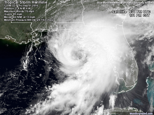
Tropical Storm Hermine has just become Hurricane Hermine, with the National Hurricane Center saying the storm is traveling at about 14 miles per hour toward Florida. Its winds have moved up from 70 miles an hour to 75 miles per hour. This storm is likely to create a lot of rain and wind over the long Labor Day weekend. What is so much of a concern is the tropical storm’s projected path in the days ahead and into next week.
It is one thing to say that this will be the first hurricane to hit Florida this decade. It is another point to see where the storm will hit. Then what has to be considered is where the storm will end up and it could threaten many coastal and inland cities in Florida, Georgia, South Carolina, North Carolina, Virginia and then potentially the rest of the states along the Northeast’s coast after the weekend.
Perhaps the good news here is that this is not expected to be ranked as a major hurricane. Still, any hurricane is a major storm if you and your house and belongings happen to be in the storm’s path.
Whether this hits Florida as a tropical storm or as a hurricane remains to be seen despite the storm being upgraded to a hurricane. As of Thursday afternoon there rain forecasts have been included. 24/7 Wall St. decided to take an online photo montage from Weather.com, the National Hurricane Center, ABC, and Weather Underground.
The National Hurricane Center said at its 2:55 p.m. Eastern Time update:
Data from an Air Force Reserve Hurricane Hunter aircraft indicate that maximum sustained winds in Hermine have increased to near 75 mph (120 km/h). Based on these data, Hermine is now upgraded to a hurricane, the fourth hurricane of 2016 in the Atlantic basin.
One issue of concern is that this storm puts the entire Eastern seaboard within the path. That puts cities in and around the northwestern part of Florida at the largest risk, but the states to the north also have to prepare for serious rain and wind. There are also no assurances that projected storm paths hold true in the hours and days ahead. That means that it could be worse or not as bad, and that means it could travel exactly as expected or that it could move to a different track.
If you have been watching hurricanes and tropical storms for years as an outsider, or as a person in the path of a storm, you probably know that predicting the exact weather and the exact paths are elusive.
Even if a storm does not actually pass directly over a city or an area, the rain clouds and outer bands can separate and create large rain storms. Again, the path puts many major cities in the potential path for wind and rain in the coming days.
24/7 Wall St. has covered many current and potential issues around storms and natural disasters over the years. Here are some of the key reports:
Stay tuned.

Let’s face it: If your money is just sitting in a checking account, you’re losing value every single day. With most checking accounts offering little to no interest, the cash you worked so hard to save is gradually being eroded by inflation.
However, by moving that money into a high-yield savings account, you can put your cash to work, growing steadily with little to no effort on your part. In just a few clicks, you can set up a high-yield savings account and start earning interest immediately.
There are plenty of reputable banks and online platforms that offer competitive rates, and many of them come with zero fees and no minimum balance requirements. Click here to see if you’re earning the best possible rate on your money!
Thank you for reading! Have some feedback for us?
Contact the 24/7 Wall St. editorial team.