Note that storm forecasts often change in severity, direction and in the type of damage expected. After all, we are talking about meteorologists rather than people who can really see the future.
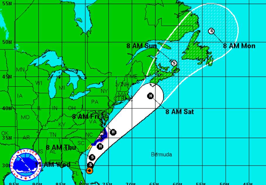
Unfortunately, this puts part of the Eastern Seaboard on watch. The storm started off the east coast of Florida. It currently is projected to put part of South Carolina and then most of the coastal areas of North Carolina on watch in the next 36 hours. The current cone path then would have it not running its actual storm path on the coast above North Carolina until it moves toward parts of the Canadian provinces of New Brunswick and/or Nova Scotia on Saturday (see below). Then it is expected to slow to a tropical storm again before posing a risk to the easternmost parts of Quebec province and then Newfoundland and Labrador.
How this storm plays out remains up for grabs as of now. If history dictates anything, it is that storms can go in different paths than projected, they can rise much more in strength, or they literally die unexpectedly in a very short period.
ALSO READ: 10 American Cities That Hurricanes Could Devastate
Unfortunately, Tropical Storm Arthur is now going to put people at risk in the eastern United States and Canada, and it is happening over the Fourth of July weekend holiday. The official outlook in May was for three to six hurricanes in 2014.
Back around Hurricane Sandy, we ran a list of the property and casualty insurers with the most risk to that storm. The expandable infographic below from NOAA shows the projected path and strength outlook as of 11 a.m. Eastern Time for Tropical Storm Arthur and then for what is expected to be Hurricane Arthur.